Friday, August 16, 2013

Tubahin Beach

Tubahin Beach
N13°55.1841' E121°44.4634'

Sitio Tubahin in Brgy. Ibabang Polo in Pagbilao Grande Island is a host to nice beaches. At least one was developed into a resort with open cottages/sheds made of nipa and bamboo among its facilities. It is accessible to vehicles through the concreted barangay road, then through an unpaved private road at a distance of approximately 2 km from the junction.
Entrance fee is PhP20 per person. Parking fee is at PhP40. Cottages may be rented at a reasonable rate (it varies). During peak season in summer months, a canteen is put up where beachgoers may order food and drinks. During lean months however, the canteen does not operate but the food may be ordered from the caretaker and is then cooked and shuttled from a restaurant which they also own. 


Freshwater for bathing is trucked-in and has to be bought also.


The beach looks brownish but becomes white when the sand gets dried under the sun

In the far background is the Pagbilao Power Station in Sitio Capalos
Some outdoor lovers however would prefer to enjoy nature in its natural state, i.e., bare and with no facilities. A few minutes walk going farther northwest from the resort (about 500meters more) a longer and wider beach exist. Vehicles may be used but can only only reach part of the way and the rest of the access has to be on foot. But why bother with the long hike when this place is always accessible by boat either from Daungan, Bantigue or Maruhi in Angas Point? 


The beach is about 150meters long. Best of all - there are no entrance fees (for now). Trees provide shade against the sun. Everything from tents, mats and other gears and provisions must be brought in.


View facing northeast showing the long and wide beach with fine brownish sand

View facing southwest showing where a creek meets the sea


With the camera hugging the ground, the fineness of the sand is seen
A farming family lives in the parcel of land bounded by this beach. Leaving a little amount for clean-up is recommended.

There is no fresh water near the beach, but there are public faucets along the Quipot-Capalos road.


How to get there?
The access to Tubahin Beaches is along the Binahaan-Quipot-Capalos Road which is the access road to Pagbilao Coal-Fired Power Plant. This road branches out from the National Highway; hence, part of the narrative for a nearby feature “kwebang Lampas” is reprinted here:

From Pagbilao, just follow the National Highway going to Atimonan. The first Y-junction, a few hundred meters after KM 146 and just infront of Binahaan Elementary School, is the access road to Pagbilao Coal-Fired Power Plant. It is marked by an impressive modern directional sign which looks out of place in a rural setting. So follow that sign which tells you to take the junction to the right. Just a few meters therein will be a railroad crossing without a safety barrier, so stop, look and listen. You will notice that the road's kilometer posts are not related to the ones in the main highway. Be watchful of road humps strategically placed at school zones, barangay centers, pedestrian crossings and dirt road junctions.


The concrete road passes thru Brgy. Binahaan. Then, going across the Spillway over Locohin River will take you thru a winding and rolling road within Brgy. Kanlurang Malicboy. In the vicinity of KM8, you can leave the Island of Luzon without having to fly or to swim, because Quipot Bridge is there to connect Brgy. Kanlurang Malicboy in the Luzon mainland and Brgy. Ilayang Polo in Pagbilao Grande Island.

After driving for about 4km thru the Island, find the Sitio Tubahin marker to your right. Enter the concrete barangay road. After about 1.2km, veering to the right from this road is an unpaved private road which is the access to the resort. After half a kilometer is the entrance to the resort. After a farther 500 meters northwest is the other beach with no entrance fee.

Photos and Narratives by 
Engr. Gerry B. Lontok ©2009

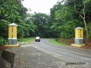
Turn right at this corner marked by the Sitio Tubahin Welcome Marker

Sungawan Cave

Sungawan Cave
N14°01.4980' E121°39.9260'
The Sungawan Cave got its name probably from its many holes or "windows" - literally "sungawan" - a hole to look through or emerge from.

The cave becomes a picnic spot usually during the lenten season only. Hence, this is a nice place for adventurers who want an uncrowded liesure spot. The water is so cold and relaxing.

How to get there?
To find the access to Sungawan Cave, you must take note that the cave is not popularly known by that name among all residents, particularly those living by the roadside. We got that name from the farmer Mang Popoy who lives in a farmhouse near the trail to the cave. The name is even pronounced as "Sung'wan". You may just ask around about "the cave in Añato" from the residents of Barangays Bigo and Añato. Residents will gladly instruct you to follow the barangay road which starts near the Barangay Hall of Barangay Bigo. This road is the Bigo-Añato barangay road. Expect that some residents may use the term "Feeder Road" instead of barangay road. 

Barangay Bigo can be reached from Pagbilao by following the Provincial Road northwest going to Tayabas. After approximately 3.5 kilometers from Pagbilao town proper, you should have passed thru the Welcome arch of Barangay Bigo. Upon finding the Barangay Hall to your right, you will also find that the road to the cave and the Barangay Hall are just in one location.

From the provincial road, turn right at the barangay road. The road will pass between the Barangay Hall of Bigo and the ubiquitous basketball court. Go up this road to Barangay Añato until the road is no longer passable. As of trek time (June 2005), the vehicle-passable road is only up to about 2.8 kilometers from the road start at Bigo. Although 4x4 vehicles may go beyond the 2.8 kilometer mark, it is not recommended as there is no other ideal parking area.

The best transportation to use here are mountain bikes as you can ride farther up to the Bangkatan River. Otherwise, you must leave your vehicle where the road will allow and walk the rest of the way. There are cluster of houses at the reachable part of the road where you may entrust your vehicle to the residents. Meanwhile, a mountain biker would enjoy a further 1.1 km ride which is preferable than walking.

At the point where the trail reaches a rice paddy by the Bangkatan River, mountain bikes may be left at the farmer Mang Popoy's hut (This is only a rest-hut, his farmhouse is the one you should see earlier along the trail). The rest of the way to the cave is a walk along and within the river for about 700 meters.

It would be interesting to know that Bangkatan River water comes from inside the Sungawan Cave. The Bangkatan River will become the Tambak River farther downstream and would wind its way around the eastern and southern outskirts of the Pagbilao town proper.

TIP: Strong lights or lanterns are a must to enter the cave. A helmet or hard hat is recommended to protect your upper head. As in any other unfamiliar caves, you would need a guide which you can ask from among the residents along the road in Brgy. Añato.


Spelunking, anyone?  

The mouth of Sungawan Cave is where Bangkatan River emerges from. Indeed, sungawan - where something emerges from.


One of the numerous holes where one can take a peek inside the cave (another meaning of Sungawan). You can even jump into this hole to go inside the cave.

The ever present water inside the cave


Emerging from one of the holes in the other side of the cave is a breathtaking experience
See Sungawan Cave Feature at WaypointsDotPH
See Sungawan Cave Vicinity Map at WaypointsDotPH


Photos and Narratives by 
Engr. Gerry B. Lontok ©2005

Pagbilao Church

Pagbilao Church
(St.Catherine of Alexandria Parish Church)

N13°58.314´ E121° 41.204´ Elev: 29m

The St. Catherine Parish was established by Franciscan Missionaries in 1685 who landed at a site now called Dinaungang-Pari. It had its beginnings in Barangay Binahaan where a church made of bamboo with cogon grass thatch roof was built in 1688, administered by Fr.Cristobal Mortanchez. In 1730, the church was moved to its present location with St.Catherine of Alexandria as Patron Saint, and Fr. Francisco Xavier de Toledo was the Parish Priest.

Building of the present stone church began in 1845 under the administration of Fr.Victorino Peralija; And was completed including the bell tower and two-story convent in 1877 under the administration of Fr.Eugenio Gomez. As an aftermath of World War II, it was destroyed during the Liberation in 1945 when American airplanes dropped bombs with the "intelligence report" that Japanese soldiers were still hiding inside the church. The convent and the church were destroyed. Fortunately the bell tower survived while the facade was heavily damaged. Repairs were done in 1954 under the Administration of Fr. Vicente Urlanda.

Subsequent repairs and additions changed the appearance of the church. The photos below partly inspired the design of the rebuilding of the second floor of the parish rectory, which has not been rebuilt for so many years after it was destroyed during the war. These photos show how the church and the rectory looked like before the War. Mr. Owen Batocabe, a mighty tenor in one of the church choirs, has kept these photos which he said were owned by his amama (grandfather):

Old photos taken September 1941, three months before the Japanese Imperial Army invaded the country
How to get there?
St. Catherine of Alexandria Parish Church is not easy to miss. Located just in front of the Municipal Building at the center of Pagbilao, it is found on the left side of Rizal Street (National Road) when you are facing the direction to Bicol. Of course, it would be to your right side when you are facing the other direction. Pagbilao is nine kilometers east of the provincial capital Lucena City. Further to the west beyond the mountain is the town of Atimonan. Padre Burgos is further southwest along the sea coast. Tayabas is in the northeast via a picturisque road amidst coconut trees while Mauban is farther up north by turning right at a junction before Tayabas. Links to WaypointsDotPH are placed at lower part of this page where you may see a Map and more photos of this feature. You may click those after reading thru this page.


A New Look
In 2003, many parts of the ceiling, including the choir loft, of the St.Catherine Church were found to be pestered with termites. This prompted the parish to dismantle the ceiling for repairs. At first, only the ceiling was to be repaired. But a total renovation was done when contributions and pledges poured in. Not only was the ceiling replaced but the intierior of the church was totally refurbished. The facade was also made to look closely similar to the original appearance using "adobe" blocks. The old photos above were brought out of the "baul" at the time final completion is being done. Hence, these were very useful in the final design. Here are the before and after photos:

St. Catherine Church facade in 2002 prior to renovation

St. Catherine Church interior in 2002

St. Catherine Church facade in 2005. Note the new stained-glass windows

St. Catherine Church interior in 2004
The renovation would not have been possible without the whole-hearted support, monetary and spiritual, from individuals, companies, anonymous donors from here and abroad. While we have enough space to mention all those names, I am just afraid to inadvertently omit any one of them. Hence, let it be known that it was the Parish Council for Economic Affairs (PCEA) with able support from the Friends of St. Catherine of Alexandria (FOSCA) who pooled their efforts to solicit from numerous donors resulting to the success of this project. But worth mentioning are the two men who devoted their valuable time - time that is priceless and irreplaceable. Mr. Boy Orgas who supervised the works and Pagbilao's artist Mr. Pabs Glodoviza. The two painstakingly thought of innovations to design and renovate the church. While the project looks complete, the pledges are not yet complete. May the God's grace and blessings come unto you, brothers and sisters. 
 
The Parish Rectory Project
painting by Darius
Have you or your family been chosen to be a member of the 294 Club? The parish rectory or "bahay-pari" has not been restored since the church was rebuilt in the 1950s after it was destroyed during the Liberation. During the time of Msgr. Dennis Imperial, what started as a simple repair of termite-infested ceiling has led into a majestic renovation and restoration of the "old look" of the Church. Time goes by, the improvements would be continuing.
Please call the Parish Office (+63 42 731 1279) to know how you can help.
See Parish Rectory (Bahay-Pari) progress photos at Yahoo! Photos
See Pagbilao Church feature at WaypointsDotPH
See Pagbilao Church Vicinity Map at WaypointsDotPH
See Pagbilao Church's artist Pabs Glodiviza's website


Photos and Narratives by 
Engr. Gerry B. Lontok ©2004

Malicboy Church

Malicboy Church
(St.Anne Parish and Diocesan Shrine)

N13°58.8240' E121°47.3570' Elev: 17m 


The St. Anne Shrine is visited by devotees and pilgrims with their faith that attending the Novena in this church answers their prayers. Novenas are held every Tuesday and there is a particular dedication/blessing depending on which Tuesday it is:


First Tuesday of the month: For those wanting to conceive and have children
Second Tuesday of the month: For Pregnant Women
Third Tuesday of the month: For Babies and Children
Fourth Tuesday of the month: For Couples in love
Fifth Tuesday of the month: For the Whole Family


St. Anne Shrine facade as seen from the Highway


Interior of the Saint Anne Shrine


Image of St. Anne at the church altar

Image of St. Anne in the candle garden

How to get there?
From Pagbilao, just follow the National Highway going to Atimonan. Go past the Y-junction at Binahaan by taking the left branch. After KM post 148, notice that the road goes straight for a long stretch. Go past Locohin Bridge (Binahaan Bridge). In the vicinity of where KM post 149 used to be is a right turning curve. Along this curve is Malicboy Bridge. After the bridge, the road goes straight again for as far as you can see. Then the road comes with a a left turning curve.

Along this curve, find St. Anne Shrine on the left side. Also in the same vicinity is the Barangay Hall of Silangang Malicboy which you would find to your right. You must exercise extra caution when driving to the parking area or walking across the road , since this part of the highway is a "compound curve", meaning after the left turning curve, a right turning curve immediately follows. It other words, be cautious of incoming vehicles and the ubiquitous motorcyles. 


History
The St. Anne Parish was officially established on 17 March 1958. But as early as 1908, in a place in Malicboy where there is a group of houses called "Grupo", the yearly celebration of the fiesta was started.

The very first church (ermita) measured 6m x 10m had no walls though it had tin roof. It was built on the lot owned by Silverio Merluza.
 

The Grupo led by Pio Dimalaluan and Enrique Glorioso agreed to seek the help of Lino Castro, who is from the town proper and owner of the farm cultivated by Pio. Lino was the one who would invite a priest to say mass for their fiesta. Father and daughter Lino and Ana then arranged that the fiesta mass on their farm be held on Ana's birthday which is July 26. On that day Ana Castro brought the picture of her patron saint St. Anne. From then on, Ana brought the picture every year until she had it enshrined in the ermita under the care of Pio.
Through the years, the ermita became dilapidated and was later destroyed by a strong typhoon. The picture of St. Anne was also damaged.

Before World War II, the elected Barrio Captain Vicente Batilo, together with his constituents built a new ermita on top of a hill to make it nearer to the community. People started building new houses around the then newly constructed train station. During these times, Ana hired an artist from Lucban, Lucilo Empamano, who decorated the ermita every year during the fiesta.
 

During the war, the ermita was in this location and the yearly celebration was never missed. The sorrounding area was even used as a cemetery during the hostilities. Until such time that the structure was destroyed by termites, Malicboy had no permanent church. For quite a long time, the yearly mass celebrations was held under a temporary bamboo frame erected wherever they could arrange for space.
 

In 1948, another ermita was built in Sitio Magsaysay on a lot owned by the Marquez family, But it was again damaged only after a year.
 

Later, on a lot inherited by Angel Glorioso from his father Enrique, a new wooden ermita with tin roof was built. This area used to be situated behind the houses and a warehouse owned by a Chinese businessman.


St. Anne Church in 1950s
Photo lifted from 25th Anniversary
(1958-1983) Souvenir Program

St Anne Church prior to the 1993 renovation
Photo lifted from Church Dedication Program
15 July 2000

The couple Angel and Canding (Catapat) went on to have the ermita built. The structure was made sturdy with wooden walls. That was in 1952. In April of that year, a stranger had his car broke down near the railroad crossing which is near the couple's house. The occupants are from Pampanga and were selling Chist the King images. The strangers stayed in the couple's house for the night. By next day, an order was placed for an image of St. Anne based on the picture left behind by Ana Castro-Martinez. In May of that year, the new image was delivered. The image did not have an infant Mary yet because the picture on which it was based from could be representing the time that St. Anne is still single.

With the image of St. Anne, the people were inspired to improve the ermita. Many contributed wooden planks for the walls. Dr. Rafael Borja donated the lacking wooden planks to have the walls completed in time for the fiesta of 1952.

A few months after the fiesta of 1957, with advise from Rev.Fr.Vicente Urlanda, the people requested from Most Rev. Bishop Alfredo Ma.Obiar for St.Anne Church to have their own priest. With the arrival on 17 March 1958 of Rev.Fr.Severiano G. Salvania as the first parish priest, the Parish of St.Anne was founded and under it were Barangays Ilaya & Ibabang Binahaan, Ilaya & Ibabang Pulo and Silangan & Kanlurang Malicboy. From then on, the parish improved with a convent built in 1959. Also, the lot was elevated to avoid getting flooded


In 02 July 1960, the corner stone was laid for the new parish church. As years passed, the construction was continuing and the parish was able to acquire adjacent lots with generous help from parishoners. The church was completed and blessed in 25 July 1983. With the increase of parishoners, including devotees and pilgrims from other areas, the church renovation started in 1993 and was completed in 14 July 2000 together with the Evangelization Hall, candle stands, comfort rooms, fencing, patio and priest's residence. The church was blessed and dedicated in 15 July 2000.

In 04 January 2000, in the year of the Great Jubilee, the St.Anne Shrine was dedicated by Most Rev. Ruben T. Profugo as a "Jubilee Pilgrim Church".

References used with permission:
- Parish of St. Anne 25th Anniversary (1958-1983)Souvenir Program
- Church Dedication Program 15 July 2000

50th Anniversary
On 15 March 2008, the St.Anne Parish, under parish priest Rev.Fr. Raphy Tolentino, celebrated its 50th anniversary as a parish. The guest of honor was no less than the President of the Republic of the Philippines. It is a very rare and unusual occasion that the President would grace an event like this.

More photos by Gerry Lontok of the President's visit may be viewed at www.pagbilawin.com - a website maintained by US-based Glenn Maningas.
If your browser requests for password,
please click here: www.pagbilawin.com


The St. Anne Parish is being served (since February 2009) by parish priest Rev.Fr. Ruel V. Abuel, a native of Atimonan and previously assigned at St. Jude Thaddeus Shrine, Cotta, Lucena City.

photo: Judy Lontok-Simbajon


See St.Anne Shrine Vicinity Map featured at WaypointsDotPH


Photos and Narratives by 
Engr. Gerry B. Lontok ©2005

Sibatiya Cave

Sibatiya Cave
N13°55.5880' E121°46.6960'

The Sibatiya Cave is located in the mountain at the center of the Pagbilao Grande Island. It is just one of about 75 caves in the area. Most of these caves has been explored and exploited for their natural fertilizer – guano or bat shit. Sibatiya is said to be the longest and the only one where you can go through the openings at both ends. The name is said to be derived from the basins of water which used to be there before the cave was plundered by guano gatherers. Although there are still remnants that could be found of those basins, most of those disappeared due to the destruction of some stone formations at the bottom of the cave. Some folks also call the cave as “bayawak” and the whole mountain as “halimaw”.

It is always advisable to get one of the local residents as a guide, who will guide you thru the 560m hike to the base of the mountain and then the climb to elevation 100m. The cave generally runs west to east; hence, for this narrative we named the two mouths as such. At the west mouth is a nice view of Pagbilao town proper and Mount Banahaw, but lush vegetation prevents an unobstructed snap from the camera. The depth of the cave is approximately 320m. This figure is the straight distance between the two mouths by GPS, disregarding curves and turns inside the cave. But we verified this to be quite accurate when our guide revealed that during the “guano years” four rolls of electric wire (PDX wire at 75m/roll) was used along this length to illuminate the cave using generators.

Inside the cavernous chamber, the crystalline stalactites and stalagmites and other odd-shaped limestone formation triggers the imagination. Oh, by the way, when stalactite and stalagmite meet and connect, they are called column
(lessons learned from Engineering Geology - MSEnverga University).
MEMORY GUIDE: Stalactite : "C" is Ceiling
Stala
gmite : "G" is Ground


The mouth at the west end.
Magical shadow created with mixing of light and darkness.

Towards the mouth of Sibatiya Cave showing monstrous stone formations.
The exploitation and plunder of the guano (bat shit) created deep ravines requiring extra caution when traversing the cave.


The cave branches here and you have to choose which way.
Need not worry, these paths would meet again.

“BACK OFF” - My friend, Roger Percol,
seems to tell the “monster” stalactite.

The proverbial “light at the end of the tunnel” is experienced here as you walk towards the east mouth.

My friend  serves as a scale to show the size of the east mouth of the cave.

We were told that the east mouth of the cave was man-made, i.e., excavated for the convenience of the guano boys. At this end is a rewarding view of Pagbilao Chico Island with the famous “Tulay Buhangin”- a sand bar that provides a natural bridge between Chico Island and Grande Island, and was a favorite movie location (before it was occupied by settlers).


Some of the movies shot on location at Tulay-Buhangin:
"ISLA" directed by Celso Ad Castillo,
"Ang Mahiwagang Daigdig ni Pedro Penduko" starring Ramon Zamora
From the mountain atop the cave, there is also a rewarding view of the Quipot area.- You may see that in the Quipot Bridge feature


How to get there?
The trek stark for Sibatiya Cave is along the access road to Pagbilao Coal Fired Power Plant. This road branches out from the National Highway; hence, part of the narrative for a nearby feature “kwebang lampas” is reprinted here:

From Pagbilao, just follow the National Highway going to Atimonan. The first Y-junction, a few hundred meters after KM 146 and just infront of Binahaan Elementary School, is the access road to Pagbilao Coal-fired Power Plant. It is marked by an impressive modern directional sign which looks out of place in a rural setting. So follow that sign which tells you to take the junction to the right. Just a few meters therein will be a railroad crossing without a safety barrier, so stop, look and listen. You will notice that the road's kilometer posts are not related to the ones in the main highway. Be watchful of road humps strategically placed at school zones, barangay centers, pedestrian crossings and dirt road junctions.


The concrete road passes thru Brgy. Binahaan. Then, going across the Spillway over Locohin River will take you thru a winding and rolling road within Brgy. Kanlurang Malicboy. In the vicinity of KM8, you can leave the Island of Luzon without having to fly or to swim, because Quipot Bridge is there to connect Brgy. Kanlurang Malicboy in the Luzon mainland and Brgy. Ilayang Polo in Pagbilao Grande Island.

After driving for about 1.7km thru the Island, watch out for these landmarks: 1) The high voltage power transmission line is crossing the road at an angle from a steel tower at your right side. 2) There are two successive Welcome Markers at the right side saying “Sitio Litugan” and “Sitio Piña”. 3) There are two successive road humps with black and yellow paint. 4) There is a narrow concrete road uphill to your left. Along these landmarks, lies the trek start point for Sibatiya Cave (see photo at right).

The trek start point with the landmarks as mentioned. Sibatiya is to the left of this road.

See Sibatiya Cave Feature at WaypointsDotPH

See Sibatiya Cave Vicinity Map at WaypointsDotPH


Photos and Narratives by 
Engr. Gerry B. Lontok ©2007

Quipot Bridge

Quipot Bridge
The place derived its name from the Tagalog term "kipot" which means narrow. It is indeed the narrowest part of the sea between Pagbilao Grande Island and the Luzon mainland. Aside from this narrow strait between the the two land mass, the name also refers to Sitio Quipot in Brgy. Ilayang Polo. While others may think, this is just a place where a wonderful bridge was built. That is because they have not stopped there to admire the view.

View from the causeway toward the island. The town of Padre Burgos can be seen at a distance. The farthest left of the small islands in the bay is known to local residents as belonging to actress/TV host/olympic swimmer Christine Jacob. She was said to swim from here to her island.
How to get there?
 
Getting there is similar to what was described in the Kwebang Lampas feature, because you have to pass thru Quipot to get across the island.

From Pagbilao, just follow the National Highway going to Atimonan. The first Y-junction, a few hundred meters after KM 146 and just infront of Binahaan Elementary School, is the access road to Mirant Pagbilao Coal-fired Power Plant (an Independent Power Producer). It is marked by an impressive modern directional sign which looks out of place in a rural setting. So follow that sign which tells you to take the junction to the right. Just a few meters therein will be a railroad crossing without a safety barrier, so stop, look and listen. You will notice that the road has its own kilometer stones not related to the ones in the main highway. Be watchful of road humps strategically placed at school zones, barangay centers, pedestrian crossings and dirt road junctions.

The concrete road passes thru Brgy. Binahaan. Then, going across the Spillway over Locohin River will take you thru a winding and rolling road within Brgy. Kanlurang Malicboy. In the vicinity of KM8, you may leave the Island of Luzon without having to fly or to swim, because Quipot Bridge was there to join Brgy. Kanlurang Malicboy in the Luzon mainland and Brgy. Ilayang Polo in Pagbilao Grande Island. There is a residential area just after the bridge. That is a resettlement area which is National Power Corporation's social engineering project in connection with the power plant construction.

View over the bridge towards the mainland clearly shows the width of the strait between the Luzon and the island. In the old days when the bridge is not yet here, farm animals like horses and carabaos were made to swim this short distance rather than let them suffer the difficulty of boarding a boat.

View of the bridge from the island

Right after crossing the bridge, there will be a climb over a hill then the road suddenly goes downhill. WARNING: The resettlement site is located on both sides of the road right at the bottom of the hill, where you might gain uncontrollable speed. Expect people crossing particularly children. Resist the urge to speed up aided by gravitational pull. Even bikers tumble down here after avoiding children.

But don't despair, If you really want a downhill ride, just a few kilometers away (no longer within Quipot), here is a part of the road colloquially called "aluyan" (hammock) because it is shaped like one.


Ride down as fast as you safely can and feel the momentum bring you up to other side of the hill.


Photos and Narratives by 
Engr. Gerry B. Lontok ©2002

Quezon National Forest Park

Quezon National Forest Park

The Quezon National Forest Park (QNFP) is a 983 hectare forest reservation by virtue of Proclamation No. 594 dated 05 August 1940 and NIPAS ACT R.A. 7586 dated 01 June 1992. It is traversed by the zigzag road which is part of the National Highway between Pagbilao and Atimonan. It is passable to any type of light vehicles. Trucks and buses are discouraged from using this road. This road has been in existence before the war and was used by the Japanese invaders to move their war materiel after they landed at Lamon Bay in Atimonan. Click Palsabangon Bridge at the bottom of this page to see related story.

How to get there?

The best way to get there to enjoy the view and smell the fresh natural scent of the fresh mountain air is on a racer or mountain bike just as the members of Pagbilao Bikers Club regularly do. But of course,you can just be boring and use your polluting, gas-guzzling vehicle.

From Pagbilao, just follow the National Highway going to Atimonan. I am going to guide you though on several Y-junctions along the way which may confuse you.The first Y-junction, a few hundred meters after KM 146 and just infront of Binahaan Elementary School, is the access road to Mirant Pagbilao Coal-fired Power Plant (an Independent Power Producer). It is marked by an impressive modern directional sign which looks out of place in a rural setting. Going to the right will take you to the the power plant, so take the left.

The next junction is the one going to Padre Burgos just infront of the Quezon National Agricultural School. It is marked by a politically- initiated welcome arch. Going thru the arch on the right will take you to Padre Burgos, so take the left once more. Now, the school's fence will be along the highway's left side. Use that fence as your guide. Once you reach the end of the fence you will find Amao I Bridge (Amao One). This time, turn right on the Y-junction immediately after this bridge. Going left will take you thru the Diversion Road which will also bring you to Atimonan but without seeing the Forest Park. After a few hundred meters, before reaching Amao II Bridge (Amao Two), find the Rest Area to your left. The area is labeled Environmental Rest Area Park (ERAP). But with the country's changing political climate, that name may not stick, so be familiar that this place is within Sitio Amao in Brgy. Silangang Malicboy, Pagbilao. There is a canteen on the right side of the road where you can buy your food if you did not bring your own. Be watchful of deadly stares if you failed to properly dispose your trash
What have we got?

Concrete picnic tables are available. The Park Administration Office is also located here. Most student tour groups start from this area. From here, they hike up the road up to where they do their activity such as tree planting. Many bikers also reinvigorate themselves here before the lung-bursting uphill climb ahead. The zig-zag road at QNFP is popularly known as Eme (Spanish for the letter M). The name was said to be based on the shape of the road. I have been trying to visualize the letter M since I was a child. The closest to an M, but not perfect, is the one in the vicinity of KM 154 (pictures below). It is indeed an M but with the peaks distorted. Some publications also call this zigzag road 3M or Tatlong Eme. That makes me more confused because if I had difficulty finding one letter M, how about three? If the road shape will be used as basis, Bitukang-manok could be more appropriate. But as it was already popular, the name Eme sticks.

Kennon Road is a just piece of cake, try Eme Road

That is what I would say I you were able to negotiate these kind of curves. Compared to the more famous Kennon Road in Baguio, the Eme Road in Quezon had sharper hairpin curves. Kennon just happens to be longer, but buses going to opposite direction can easily negotiate its curves with care. Here, vehicles have to wait for the upcoming ones use the curves one after the other. Maybe Kennon had deeper ravines. It was because there are no trees to block your view of the bottom of the cliff. In the photo below, three road levels are in just one location. Have you seen this kind of view before?
Keep Left There is a traffic rule in the zigzag road that most city-bred drivers do not know or fail to follow: If you are going downhill and the road turns into a hairpin curve to your left, you shall KEEP LEFT to the the inside of the curve (like the black SUV in the above photo was doing). Stop and wait there, so that if there is an upcoming vehicle, it can use the outside of the curve with a wider turning radius. When it is your turn to proceed, it is easier for you to use the outside of the curve downhill. As a general rule, upcoming vehicles have the right of way. There are at least two locations in QNFP with this "KEEP LEFT" rule, one for each direction. So you need to follow that rule only once per pass. There are volunteer park aides to guide you in almost all road curves, be it hairpin or not. For God's sake, obey their flag signals. Who cares if, for not following traffic signals, it is you who will fall to the ravine and take days to be recovered (Hoping you have no passengers). But please, think of the other people in the upcoming vehicle. I have to say this because I have seen drivers in flashy cars disobey the park aide and endanger himself and the upcoming vehicle.
 
Yes, the volunteers recieve no salary (that is why they are volunteers). Dropping a coin or two as you pass will be appreciated. As regular bikers, we pathetically observe that the more expensive the cars are, the less likely for its occupants to give a token of appreciation (and livelihood) to the park volunteers. Maybe we need to understand, they are still paying for the amortization.
Buenavista Spot Magnetic Road
About 700m after KM 154, another part of Eme Road was develepod for its "good view" - buena vista in Spanish. Not far from here is a parking space with concrete picnic tables. After parking your vehicle there, walk back to this roadside to admire the aerial view of Pagbilao, Pagbilao Bay, Patayan Island and far away Lucena City. ("Patayan" is pronounced similar to "Tapayan" - maybe to get away with the meaning related to "killing")
Look at the picture above. Tell me if the road is downhill. If you answer yes, stop your vehicle a few meters before KM155, put your gear into neutral and get ready to roll down. If you rolled forward, you win, your guess is right that the road is downhill. But I bet, the magnet hidden under the mountain will attract your vehicle to roll backwards. (Of course, there is a more realistic explanation for this but we don't need to tell you to let the magic remain)

View from Atimonan
This new boundary monument (05 June 2004) marks the road boundary between Pagbilao and Atimonan


Photos and Narratives by 
Engr. Gerry B. Lontok ©2004

Palsabangon Dam

Palsabangon Dam
This Dam was built across the Palsabangon river to raise the water and irrigate the ricefields in Ilaya (North) and Ibabang (South)Palsabangon.

The dam holds a reservoir that offers a nice swimming place for picnickers. The top of the dam is a favorite spot to do one's laundry. No advertiser have noticed yet, but maybe someday a laundry detergent commercial could be filmed here. The apron doubles as a "kulahan" for sun bleaching of blankets and curtains.


The Palsabangon Dam viewed from downstream

How to get there?
Access to Palsabangon Dam from the highway is from a similar point as described in the Kagbuho and Kamaluya. features:
After about 4 km eastbound from Pagbilao town proper, look out for the high voltage transmission lines of the National Power Corp crossing the highway about a hundred meters after KM142. While you could already see gigantic towers even before reaching the area, don't be confused as the wires cross the highway only in that vicinity where you will find a Barangay Road branching out to your left. At this point, the highway goes uphill and curves to the right. There is a limited line of sight against incoming dowhhill traffic which is dangerous while you are attempting to swerve to the left. Thus, it is suggested that while still far away from the said curve, you may carefully swerve to the left when the road is clear and use the shoulder to "crawl" to the start of the Barangay Road. That way, you will keep the main road free. Don't forget to turn on your hazard lights to warn oncoming vehicles that you are staying on the shoulder. Likewise, don't turn your headlights on as it may confuse the incoming vehicle that you are coming back to the pavement. Thru this Barangay Road, proceed to the residential area (locally known as "Boyet") at Brgy Ilayang Palsabangon. It is about 1.1 km from the highway. You will have to park your vehicle in that area as it where you may have someone to watch it. As the road up to this point is concreted, tricycles ferry passengers from the town proper for only P5 each. If you prefer that way, you don't have to have your vehicle eat up the limited parking space at "Boyet".
 

From hereon, the dam can be reached by hiking and fording the river upstream for 30 minutes. Since the river has numerous bends, there are points where you may climb the bank and go down the river again at the other side of the bend. For that purpose, you will need a guide.
 

Without a guide though, it is natural to find a trail to climb up the bank when you notice a heavy river curve up ahead. Facing upstream, it is logical to find right turning river to have a short-cut trail on the right bank.
The water in the reservoir and the cascade that spills over the dam radiates a cooling effect that makes taking a rest at the abutments very enticing, like this pupuyan gatherer was enjoying.

The leaks in the stop logs at the sluice gate in the center of the dam becomes an artificial waterfall that children enjoy frolicking with.


A view of the the reservoir invites you to take a plunge. But make sure you have lifeguards among your group.

Photos and Narratives by 
Engr. Gerry B. Lontok ©2003

Malicboy Falls

Malicboy Falls
N13°59.8390' E121°46.8340'
Malicboy Falls is one of the most frequently visited picnic spots in Pagbilao. One needs only about thirty to forty-five minutes walk to reach the Falls. Students of nearby schools such as the Quezon National Agricultural School are frequent visitors

While the Falls was previously visited by this webmaster long time ago, it was only after three years since this website went online (10/30/2000) that the Malicboy Falls was featured. I have been finding time (out of my spare time) to schedule a visit. Surprise of all surprises, Mr. Rufino Mercurio, the owner of the land bordering the Malicboy Falls, came to me after learning of my efforts in promoting the tourist spots of Pagbilao. He said he saw my TV interview about this website. He brought with him development plans for the Malicboy Falls. He had drawings and some preliminary permits to develop the Falls into a resort and tourist destination. He asked for my ideas about this. I replied that we can start by promoting it. The Internet will very well do that for us. Thus, we made an unscheduled trek to the falls on September 20, 2003.

Of all waterfalls featured in this website, Malicboy Falls, owing to its proximity, could have the highest potential. Mr Mercurio said he already had an investor with funds underway to build a 1.5km access road to a point near the falls.

How to get there?
Describing the access to Malicboy Falls from the highway got a little complicated when we found that kilometer post 149 which used to be "posted" nearby was missing. A resident said that it was hit by a vehicle and later pushed away by a road grader. We indeed found the KM post concrete marker under the bushes. (The DPWH should be requested to reerect Km Post 149. In the first place, why would their road grader push it away? To hide that they were not able to restore it?).
[As of Feb 2008, kilometer post 149 was observed to be already restored]

Thus, to properly describe the trek to Malicboy Falls, the best landmark to reckon with from the highway is Malicboy Bridge (located at Sta 149+200). This bridge is about 230m after the waiting shed marking the start of trek.


The Highway curve with the waiting shed that marks the start of trek. Farther down this road, after 230m, find another landmark Malicboy Bridge
From Pagbilao, just follow the National Highway going to Atimonan. Go past the Y-junction at Binahaan by taking the left branch. After KM post 148, notice that the road goes straight for a long stretch. You will not find KM post 149 (as explained earlier), so estimate that you have gone the next one kilometer after KM post 148. The vicinity of where KM post 149 used to be is approaching a right turning curve. At the left side of the highway along this curve, you will find a waiting shed (See picture above). That is your landmark to stop (or alight if you are commuting).

Now, in case you missed this waiting shed, you will easily find Malicboy Bridge after the curve. Seeing the bridge, you will know that you went past your target stop. Carefully take a U-turn and find the waiting shed earlier described. The trail beside this waiting shed is the start of the trek to the Falls.

Once you are at the waiting shed, a coconut trunk bridge crossing a creek a few meters down the trail will further confirm that you are in the right place.(The coconut trunk bridge may soon be upgraded without further notice)

There are very few landmarks in the trail to help show you the way. Asking directions may not be effective as you may simply get the generic reply "D'yan lang" ("It's just there").

You may not be as lucky as I am to have the landowner himself as your guide to the Falls. There are houses in the vicinity of the waiting shed. You may need to ask someone to serve as guide. Even children will be happy to show you the way. In the future, the access road will be built and directional signs will be installed in the "short-cuts" for trekkers. So, who needs a guide anyway?

Malicboy Falls was uploaded at WaypointsDotPH by Mr. Ed Garcia on the same day I had it documented (quite fast! - me too in submitting). GPS trekkers may simply download GPS track data from that site and upload them to their receivers and use the dumb LCD screen as guide. Find the links to WaypointsDotPH after enjoying the pictures below.

The Big Tourism Potential  


My daughter Geraldine (L) and her friend Jenerose (R) easily negotiated the 1.2km trail

The landowner, Mr. Rufino Mercurio, is very ethusiastic about promoting and developing the Malicboy Falls. Any investor may signify their interest thru the contact details in this website

After climbing an almost vertical cliff, this is the rewarding view looking down from the top of the main falls (Note the size of people in the center of the picture).
The scenery from this vantage point, if the camera would be horizontal, is also breathtaking. But why should I reward you with a photo of that? You have to hike and climb as I did.

Experience the jacuzzi effect of the cascading water falling to the pool just above the main falls


The natural swimming pool about 200m upstream of the main falls. The water shown falling in this photo comes from another natural pool shown in photo at right.


The upper natural swimming pool as mentioned in caption of photo at left.

See Malicboy Falls Feature at WaypointsDotPH

See Malicboy Falls Vicinity Map at WaypointsDotPH


Photos and Narratives by 
Engr. Gerry B. Lontok ©2003