Quezon National Forest Park
The Quezon National Forest Park (QNFP) is a 983 hectare forest reservation by virtue of Proclamation No. 594 dated 05 August 1940 and NIPAS ACT R.A. 7586 dated 01 June 1992. It is traversed by the zigzag road which is part of the National Highway between Pagbilao and Atimonan. It is passable to any type of light vehicles. Trucks and buses are discouraged from using this road. This road has been in existence before the war and was used by the Japanese invaders to move their war materiel after they landed at Lamon Bay in Atimonan. Click Palsabangon Bridge at the bottom of this page to see related story. How to get there? The best way to get there to enjoy the view and smell the fresh natural scent of the fresh mountain air is on a racer or mountain bike just as the members of Pagbilao Bikers Club regularly do. But of course,you can just be boring and use your polluting, gas-guzzling vehicle. From Pagbilao, just follow the National Highway going to Atimonan. I am going to guide you though on several Y-junctions along the way which may confuse you.The first Y-junction, a few hundred meters after KM 146 and just infront of Binahaan Elementary School, is the access road to Mirant Pagbilao Coal-fired Power Plant (an Independent Power Producer). It is marked by an impressive modern directional sign which looks out of place in a rural setting. Going to the right will take you to the the power plant, so take the left. The next junction is the one going to Padre Burgos just infront of the Quezon National Agricultural School. It is marked by a politically- initiated welcome arch. Going thru the arch on the right will take you to Padre Burgos, so take the left once more. Now, the school's fence will be along the highway's left side. Use that fence as your guide. Once you reach the end of the fence you will find Amao I Bridge (Amao One). This time, turn right on the Y-junction immediately after this bridge. Going left will take you thru the Diversion Road which will also bring you to Atimonan but without seeing the Forest Park. After a few hundred meters, before reaching Amao II Bridge (Amao Two), find the Rest Area to your left. The area is labeled Environmental Rest Area Park (ERAP). But with the country's changing political climate, that name may not stick, so be familiar that this place is within Sitio Amao in Brgy. Silangang Malicboy, Pagbilao. There is a canteen on the right side of the road where you can buy your food if you did not bring your own. Be watchful of deadly stares if you failed to properly dispose your trash |
|||||
 |
|||||
| What have we got? | |||||
Concrete picnic tables are available. The Park Administration Office is also located here. Most student tour groups start from this area. From here, they hike up the road up to where they do their activity such as tree planting. Many bikers also reinvigorate themselves here before the lung-bursting uphill climb ahead. The zig-zag road at QNFP is popularly known as Eme (Spanish for the letter M). The name was said to be based on the shape of the road. I have been trying to visualize the letter M since I was a child. The closest to an M, but not perfect, is the one in the vicinity of KM 154 (pictures below). It is indeed an M but with the peaks distorted. Some publications also call this zigzag road 3M or Tatlong Eme. That makes me more confused because if I had difficulty finding one letter M, how about three? If the road shape will be used as basis, Bitukang-manok could be more appropriate. But as it was already popular, the name Eme sticks. |
|||||
Kennon Road is a just piece of cake, try Eme Road |
|||||
That is what I would say I you were able to negotiate these kind of curves. Compared to the more famous Kennon Road in Baguio, the Eme Road in Quezon had sharper hairpin curves. Kennon just happens to be longer, but buses going to opposite direction can easily negotiate its curves with care. Here, vehicles have to wait for the upcoming ones use the curves one after the other. Maybe Kennon had deeper ravines. It was because there are no trees to block your view of the bottom of the cliff. In the photo below, three road levels are in just one location. Have you seen this kind of view before? |
|||||
 |
 |
||||
 |
Keep Left There
is a traffic rule in the zigzag road that most city-bred drivers do
not know or fail to follow: If you are going downhill and the road
turns into a hairpin
curve to your left, you shall KEEP LEFT to the the inside
of the curve (like the black SUV in the above photo was
doing). Stop and wait there, so that if there is an
upcoming vehicle, it can use the outside of the curve
with a wider turning radius. When it is your turn to
proceed, it is easier for you to use the outside of the
curve downhill. As a general rule, upcoming vehicles have
the right of way. There are at least two locations in
QNFP with this "KEEP LEFT" rule, one for each
direction. So you need to follow that rule only once per
pass. There are volunteer park
aides to guide you in almost all road curves, be it
hairpin or not. For God's sake, obey their flag signals.
Who cares if, for not following traffic signals, it is
you who will fall to the ravine and take days to be
recovered (Hoping you have no passengers). But please,
think of the other people in the upcoming vehicle. I have
to say this because I have seen drivers in flashy cars
disobey the park aide and endanger himself and the
upcoming vehicle. Yes, the volunteers recieve no salary (that is why they are volunteers). Dropping a coin or two as you pass will be appreciated. As regular bikers, we pathetically observe that the more expensive the cars are, the less likely for its occupants to give a token of appreciation (and livelihood) to the park volunteers. Maybe we need to understand, they are still paying for the amortization. |
||||
| Buenavista Spot | Magnetic Road | ||||
 |
 |
||||
About 700m
after KM 154, another part of Eme Road was develepod for
its "good view" - buena vista in Spanish. Not
far from here is a parking space with concrete picnic
tables. After parking your vehicle there, walk back to
this roadside to admire the aerial view of Pagbilao,
Pagbilao Bay, Patayan Island and far away Lucena City.
("Patayan" is pronounced similar to "Tapayan"
- maybe to get away with the meaning related to "killing")
|
Look at the picture above. Tell me if the road is downhill. If you answer yes, stop your vehicle a few meters before KM155, put your gear into neutral and get ready to roll down. If you rolled forward, you win, your guess is right that the road is downhill. But I bet, the magnet hidden under the mountain will attract your vehicle to roll backwards. (Of course, there is a more realistic explanation for this but we don't need to tell you to let the magic remain) | ||||
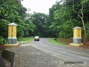
View from Atimonan
This new boundary monument (05 June 2004) marks the road boundary between Pagbilao and Atimonan
This new boundary monument (05 June 2004) marks the road boundary between Pagbilao and Atimonan
Photos and Narratives by
Engr. Gerry B. Lontok ©2004
No comments:
Post a Comment